
Floor Area Ratio: What It Is and How Local Governments Can Use It
December 3, 2025
by
Noal Leonetti
,
Abby Newbold
Category:
Guest Author
,
Comprehensive Planning-Growth Management
,
Housing
,
Transportation and Land Use
Passed during the 2025 Washington State legislative session, HB 1491 establishes new requirements for transit-oriented development (TOD) regulations within a select group of cities (counties are exempt). Chief among this, HB 1491 requires the use of floor area ratio (FAR) when setting density standards near high-capacity transit stations.
This blog is intended to be a FAR "primer," applicable for those cities that may need to implement these new metrics, as well as anyone interested in learning more.
What Is FAR?
RCW 36.70A.030(19) defines FAR as the ratio of the total floor area of a building on a given lot compared to the total area of the lot. It is usually expressed as a decimal (e.g., 2.5) or as a ratio (e.g., 1.5:1).
FAR only applies to the developable portion of the lot area, and the calculation may exclude:
- public facilities, critical areas, and their buffers;
- certain types of unoccupied spaces, such as elevator shafts, equipment floors, parking garages, and basements; and
- floors in a building that are partially below grade.
How Is FAR Used?
Unlike other density measurements, such as units/acre and lot coverage, FAR does not address building form or shape, giving developers more options. Instead, local governments often use FAR in zoning regulations to manage building density and land use, with higher FARs typically indicating higher densities.
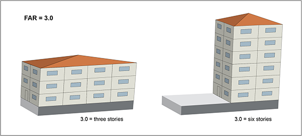
For example, if a lot has a minimum FAR of 3.0, a developer could build a three-story building that covers the entire lot (at a minimum) or a developer could build a six-story building on just half of the lot (6/2=3.0), as the image below demonstrates.
Which Cities Must Comply with HB 1491?
As noted above, only those cities with rail and/or bus (rapid transit) station areas must comply with HB 1491.
Session law defines “rail station areas” as encompassing all lots that are:
(a) Fully or partially within one-half mile walking distance of an entrance to a train station with a stop on a light rail system, a commuter rail stop in a city with a population greater than 15,000, or a stop on a rail trolley operated west of the crest of the Cascade mountains; or
(b) Fully or partially within one-quarter mile walking distance of an entrance to a train station with a commuter rail stop in a city with a population no greater than 15,000.
And “bus station areas” are defined as lots that are:
Fully or partially within one-quarter mile walking distance of a stop on a fixed route bus system that is designated as a bus rapid transit stop in the transit development plan as required in RCW 35.58.2795 […] and that features fixed transit assets that indicate permanent, high capacity service including, but not limited to, elevated platforms or enhanced stations, off-board fare collection, dedicated lanes, busways, or transit signal priority.
(Cities will need to assess whether their stations, especially bus rapid transit stations, meet the criteria for compliance.)
Compliance deadlines
Applicable cities in Clark County must comply with the new requirements by June 30, 2026, and affected municipalities in Spokane County must comply by June 30, 2027.
Cities with periodic comprehensive plan update deadlines occurring before July 7, 2025, (HB 1491’s effective date), which includes cities within King, Kitsap, Pierce, and Snohomish counties, have until either December 31, 2029, or by the deadline of their implementation progress report as mandated by RCW 36.70A.130(9) to comply. See HB 1491 Sec.3(15) for more details.
It should be noted that a local government can also choose to use FAR to measure density outside TOD areas covered by the new law.
What Does HB 1491 Require?
The law requires minimum allowable building densities for the quarter- and half-mile radius of transit stations (i.e., “station areas”).
Under RCW Chapter 36.70A, cities must allow buildings of up to 3.5 FAR (on average) in light rail station areas and 2.5 FAR (on average) in bus station areas—though cities can exempt up to 25% of bus station areas if they increase FAR to 3.0 in 75% of the area.
Cities are not required to use FAR minimums set in HB 1491; rather, local TOD regulations must allow buildings of up to the required levels. Extra FAR must be allowed for affordable units (i.e., at or below 30% of area median income).
In buildings where all units are affordable (up to 50 years or permanent supportive housing), cities must allow 1.5 extra FAR, or up to 5.0 FAR total in light rail and commuter rail stations, and 4.0 FAR in bus station areas.
Additionally, multifamily housing units with at least three bedrooms cannot be counted toward the FAR limit, to encourage more apartments for families.
HB 1491 allows jurisdictions to change the allowable FAR within the station area above or below the required allowable FAR, only if the average across all lots within the station area equals the required allowable FAR. For example, if a city with a light rail station raised the allowable FAR within .25 miles of the station to 5, the city could lower the outer .25-mile segment (between .25 and .50 miles from the station) to 3.0 and still comply with the law.
Examples of FAR Use Across the State
The cities of Seattle and Federal Way use FAR requirements to shape higher-intensity TOD, though their approaches are not quite the same as that mandated in HB 1491.
Below are some additional examples of cities using FAR in development regulations:
- Kirkland Municipal Code Ch. 15.30 describes allowable FAR as a percent based on lot size and includes great descriptors for calculating FAR.
- Port Townsend Municipal Code Sec. 17.18.030 describes FAR as “3 sf of gross floor area per 1 sf of lot,” translating this to 3.0, and does not require maximum FAR for mixed commercial/residential developments.
- Redmond’s recent significant zoning code update, Ord. 3186 (2024), includes FAR calculations in each zoning area. Also see Redmond Zoning Code Sec. 21.16.200.
Conclusion and Additional Resources
FAR is a distinct way to describe building density, providing more direction than other metrics for building form and bulk. Below are some additional resources:- Napa (CA) 2040 General Plan, Density/Intensity Standards (2022) – Describes FAR calculations and offers examples
- Metropolitan Council of Minnesota Calculating Floor Area Ratio – Details one method to calculate FAR in a building
- MRSC 2025 Legislation Affecting Local Government Planning – Covers several planning-related bills, including HB 1491
- Planetizen: What Is Floor Area Ratio? – Includes a short article and video
- Washington State Department of Commerce Transit-Oriented Development
MRSC is a private nonprofit organization serving local governments in Washington State. Eligible government agencies in Washington State may use our free, one-on-one Ask MRSC service to get answers to legal, policy, or financial questions.